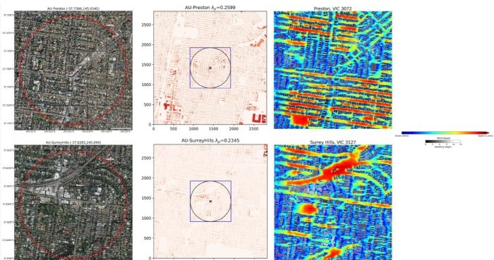
How machine learning can decode wind patterns in our cities
Imagine predicting the wind flow around you with precision – perhaps to find a refreshing breeze on a hot day or a sheltered spot when it’s chilly.
Until now, such predictions would require solving complex physical models on supercomputers – far too demanding for personal devices like phones, ipads and laptops to handle.
Researchers at UNSW in Australia have changed that. The team, based at the ARC Centre of Excellence for Climate Extremes and the ARC Centre of Excellence for 21st Century Weather, have developed a model that anyone can run – accessible, lightweight, and requiring no advanced expertise.
Now, predicting wind speeds for any neighbourhood is as simple as a few clicks. And there’s more to come! This research highlights the power of AI-driven urban microclimate analysis, paving the way for smarter, more adaptive city design.
Curious about how this could transform your city experience? Read more about the research in the journal Environmental Research Letters. The work was led by Dr Jiachen Lu and Associate Professor Negin Nazarian of the Climate-Resilient Cities Lab.
Stay tuned – a web app is launching soon. Anyone, anywhere, will be able to access it, drag and drop the map to their neighbourhood, generate a detailed urban layout, and use the model to compute a high-resolution wind flow map in seconds.

Take a closer look
Wind at the ground level is very important for shaping the local climate in cities. Wind patterns in cities are more variable than things like temperature and heat, and they depend on many factors like building shapes and the strength and direction of the wind.
Because wind is so complex, it’s been hard to model accurately at a small scale. But wind patterns are important for many aspects of city life – like making pedestrians feel comfortable in hot weather and improving city ventilation. Understanding urban wind is crucial for designing cities that are more comfortable and better for the environment.
Typically, to figure out how wind moves around cities, scientists use a method called computational fluid dynamics (CFD). This method uses complex mathematical equations to simulate wind patterns around buildings. While CFD works well, it takes a lot of computer power and expert knowledge, so it’s not always practical for regular use.
Instead of using CFD, the UNSW researchers developed a machine learning model based on UrbanTALES – the most extensive, high-resolution urban flow dataset to predict wind patterns. The machine learning model uses data on the direction of the wind and the shape of buildings, which are now available for many cities around the world.
What’s next?
There are some exciting ways this research could be improved in the future. First, adding more real-world urban neighborhoods under different weather conditions will make the model even more accurate.
The types of cities chosen for the model should also match the target area, so it can be generalised better. To improve the model itself, the researchers could make it more accurate in predicting extreme wind speeds by adjusting how it learns from the data.
Finally, adding more detailed features, like surface models, vegetation, and heat data, could make the model even more realistic and useful for urban planning.
This article was written using a combination of human and artificial intelligence.
